Freedom to map depends on WHO delivers it
In India, or anywhere else.
Map, or you will be mapped
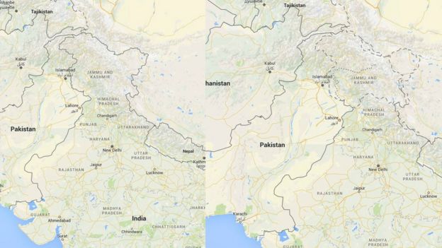
In 2016, India banned unofficial maps and satellite photos. The official goal of that bill was to regulate both the creation and distribution of geospatial information in India “which is likely to affect the security, sovereignty and integrity” of the country. This is not surprising because maps are international politics. As proof of this, that BBC article rightly notes that, “in India (left), Google Maps eliminates the Line of Control seen on the international version (right)" :
Back then, local activists denounced the bill as a draconian restriction to the “Freedom to Map India”:
In mid-February 2021, the Indian Government finally liberalised “policies governing acquisition and production of geospatial data”, in order to herald “the unlocking of geo-mapping from restrictive use to wider use."
The change was immediately celebrated by some as a radical mapping reform, thanks to which all restrictions on mapping are gone, and “Indian Startups will revolutionise mapping. Next generation hyper resolution maps will happen. $Billions value unlocked, thousands of jobs!" All stakeholders where officially invited to take advantage of “the liberalization of Geo Spatial Mapping industry and democratization of existing data sets, and thus contribute to achieve [the government’s]goal of 5 trillion dollar Indian economy." (1)
Beware the Freedom to Map…
Others are not so unconditionally happy about this reform. One is Twitter user Srikanth, who tweeted: “While decriminalisation of mapping is a welcome step, communities must now keep a watch on pro-surveillance mapping." According to him, the real reason why this specific, top-down version of “Freedom to Map” came to be is that big financial institution want to directly control mapping data, for greater control on agriculture and land property, and to “deepen geospatial surveillance in general”.
When I asked him why he thinks so, he answered (here and here) that the people who celebrate this freedom are the same who:
- made identification through the controversial Aadhaar identification scheme a necessary condition to access free digital maps of India from the Web 2.ask that India moves “from loose property descriptions by patwaris to digital GPS boundaries tagged to a unique owner” because the necessary technology, “from centimetre accuracy maps to Aadhaar” finally exists, but do not tell “how this will lead to wholesale sale of [land to?] banks and will still be funded by FDI / FII”
This post is about YOU, not India maps!
At the moment, I do not know enough about this reform and its general background, to have a definite opinion on who is wrong or right here. But that is not important. My only goal with this post is to remind everybody, in India and everywhere else, that “map or you will be mapped” is not just a fancy slogan.
Whoever draws the maps, or controls the data needed to draw them, can concretely increase, or limit, your personal freedom and rights. This is the only thing that you surely want to learn from all the congratulations and concerns above. Take them as concrete examples of what could actually go wrong, or right, with mapping laws, whatever digital map you are already living in.
- More on the “historical importance of India’s Cartography Reforms” is here
Who writes this, why, and how to help
I am Marco Fioretti, tech writer and aspiring polymath doing human-digital research and popularization.
I do it because YOUR civil rights and the quality of YOUR life depend every year more on how software is used AROUND you.
To this end, I have already shared more than a million words on this blog, without any paywall or user tracking, and am sharing the next million through a newsletter, also without any paywall.
The more direct support I get, the more I can continue to inform for free parents, teachers, decision makers, and everybody else who should know more stuff like this. You can support me with paid subscriptions to my newsletter, donations via PayPal (mfioretti@nexaima.net) or LiberaPay, or in any of the other ways listed here.THANKS for your support!