Going to Mauritius? Remember to map breadfruit trees!
A couple weeks ago, an unusual request on the Mauritius Linux Users Group caught my attention, one that may interest both tourists visiting Mauritius in the next months, and everybody interested in ICT for sustainable development.
It turns out that (see here for details), after the food price crisis of 2008, the Mauritian Government established a Food Security Fund to promote Agricultural Research and Development to improve food security. Besides increasing production of known staple crops, a long-term goal of that Fund is the identification of other interesting crops.
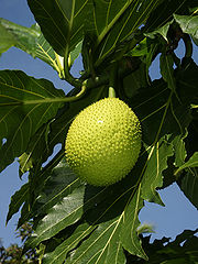
Breadfruit leaves and fruit (source: Wikipedia)

</em></u>
In that context, breadfruit has been identified as an important alternative staple crop, that could not only contribute substantially to local food security, but also become a source of income for Mauritians households and small-scale orchards. The reasons are that not only breadtree is already grown in Mauritius, mostly as backyard production, but exports to Europe have been established and proved to be highly profitable, and breadfruit could be processed locally to obtain gluten-free flour.
That was the background. Here’s the request: for all the reasons above, the Mauritius national program on Breadfruit trees is trying to map all the trees of the country as soon as possible, in an easy and fun way that is worth imitating in many other places worldwide: asking for help to everybody with Internet access in Mauritius! Here is the request that Krishan Bheenick posted to the Mauritius LUG:
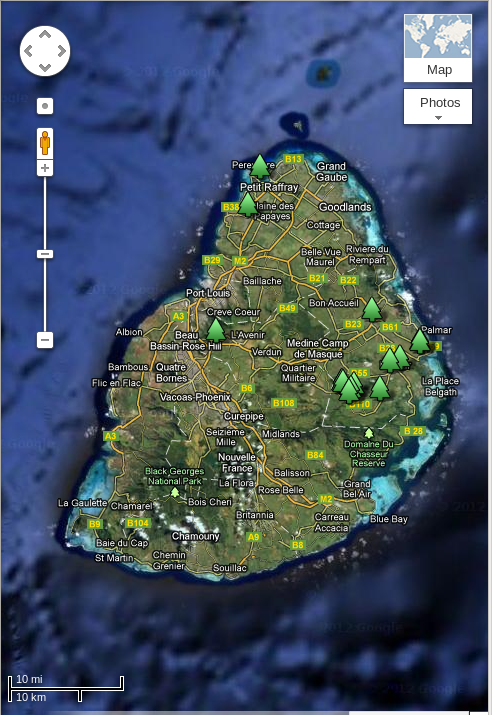
“This is the right time to identify the trees as they are quite conspicuous with the fruits already appearing on these generally huge trees with large leaves. So, we have put up a public map of breadfruit trees in Mauritius on which you can add location of trees by yourself (if you have a Google account). Catch the “breadfruit bug” and you will be like me yesterday, driving around and being amazed at how many breadfruit trees can be spotted from the road!"
This, instead, is some extra information about the goals of the program that Bheenick sent directly to me when I asked to know more:
“The first objective is to test if “crowdsourcing” is a viable method of gathering information in a spatial and descriptive manner in Mauritius (the motivation factor is a fun activity, being carried out at a time when identification of the trees is relatively easy - it also gives the contributors the option of remaining anonymous or to identify themselves). If the first stage works out, then we know we are on to something of interest and which could be built upon, hence the effort to avoid being too ‘serious’ in this exercise at this stage.
The second objective is to provide the members of the Breadfruit Sector Consortium with a map of distribution and quantity of breadfruit trees to work with, to complement statistics that may be available. (based on the extent of the development of the map - and some of the characteristics which people may fill in, the Consortium will then decide on how best to capitalize on this first exercise to build up its knowledge-base)."
I find Bheenick’s final remarks particularly interesting: “we will draw conclusions from this effort whether the process in viable in the future, and whether something similar could be integrated into school holiday exercises(?) - or whether it is of interest to University students.” My suggestion is: why not involve tourists too?
Who writes this, why, and how to help
I am Marco Fioretti, tech writer and aspiring polymath doing human-digital research and popularization.
I do it because YOUR civil rights and the quality of YOUR life depend every year more on how software is used AROUND you.
To this end, I have already shared more than a million words on this blog, without any paywall or user tracking, and am sharing the next million through a newsletter, also without any paywall.
The more direct support I get, the more I can continue to inform for free parents, teachers, decision makers, and everybody else who should know more stuff like this. You can support me with paid subscriptions to my newsletter, donations via PayPal (mfioretti@nexaima.net) or LiberaPay, or in any of the other ways listed here.THANKS for your support!